About dxtra.com Radio Database
Dxtra (pronounced dee-extra) is a portmanteau of DX (long-distance radio reception) and extra. A free tool for exploring radio stations across the United States and around the world!

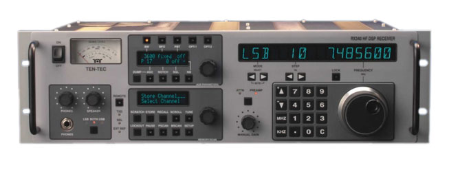
WorldStation 5.0 coming soon for the Ten-Tec RX-340. Control your RX-340 in style with a new concept in remote radio control. You will get a complete mini-PC loaded with all the databases you see here plus full web control from anywhere.
The Ten-Tec RX-340 is not only an iconic example of American industrial design, its RF (radio frequency) performance under tough signal conditions is nothing short of breathtaking. The ultimate DX dream machine. It is really a scientific instrument that adapts well to recent SDR designs that can be coupled easily to the RX-340's various IF outputs. Frequency accuracy to 1 PPM is possible with the addition of an atomic clock or GPS master clock. Full remote control over the Internet with WorldStation 5.0.
What This Site Is About
This site is dedicated to the curious little kid that lives inside all of us. The desire to know what's "out there". We start out by learning about our own backyard, then our neighborhood then the town or city in which we live. As we get older we realize there is a bigger world out there, our country and then countries beyond, other continents even. If we are lucky, we get to travel to some of these places as adults. We learn that American concepts like freedom of speech and liberty are not just abstract concepts but form the foundation of a good life. Shortwave radio is the one area of radio that can reach out across continental distances and spread news, a song or perhaps even propaganda.
Sometimes words alone don't do justice to the beauty and sheer power of shortwave radio propagation. Check out this amazing visualization of the signal of WRMI over a 24 hour period:
WRMI 9955 kHz VOACAP coverage — 24-hour cycle showing how shortwave propagation changes with the ionosphere
Its cousin, AM radio is a mainstay of local communities not just in the USA but around the world. Clear Channel AM stations can be heard across the USA at night. Try it sometime with your car radio. Commercial FM radio, although troubled by corporate overreach and consolidation in the USA, is a worldwide hit. In the USA don't forget we have a vibrant College and Freeform Radio FM scene. Use our search tools to find these stations with their amazing playlists in your local area. This is the art and science of DX'ing — hearing what is just around that corner.
This site provides detailed technical data (and visualization) for over 4,700 licensed AM and 12,000+ FM radio stations in the United States, plus UK AM/MW and FM stations from Ofcom, 22,000+ European FM stations, 4,800+ Brazilian stations from ANATEL, 3,200+ Australian stations from ACMA, 3,957 Thai FM stations from AsiaWaves, 1,100+ South African stations from ICASA, and 1,780+ Chilean stations from SUBTEL. Every station can be searched by call sign, frequency, city, state, zip code, or owner name.
For FM stations, full terrain-aware coverage maps are computed using actual topographic data, showing where each station's signal can realistically be received. An elevation profile feature shows the terrain cross-section between your location and the transmitter, with line-of-sight analysis and Fresnel zone clearance. AM stations include daytime groundwave contours and nighttime skywave reception probability based on ITU-R P.1147.
Use the My Radio feature to save your favorite stations. Click the star icon on any station to build a personalized list that persists across visits, with quick access to coverage maps, streaming audio, and a custom RSS news feed.
And please don't forget our sponsor Glassmenu™. They worked very hard to bring an outstanding and inexpensive digital signage platform to the small business community. It now integrates NOAA and IPAWS alerts related to your local community.
Great Britain Coverage
In addition to US stations, the database includes FM and AM/MW stations licensed by Ofcom in the United Kingdom. UK FM stations have full terrain-aware propagation coverage maps computed with the same Longley-Rice model used for US stations, using SRTM elevation data covering the British Isles.
UK AM/MW stations include groundwave coverage contours and nighttime skywave propagation modeling. Station data is sourced from Ofcom's public technical parameters database and updated periodically.
European Coverage
The database includes over 20,000 FM stations across 32 European countries. Most of Europe is sourced from BNetzA (Germany's Federal Network Agency) broadcast data, while France uses authoritative data from ANFR (Agence Nationale des Fréquences) covering all 105 départements including overseas territories. Each station has terrain-aware Longley-Rice coverage maps and directional antenna patterns. Browse at dxtra.com/eu.
Brazil Coverage
The database includes over 4,400 FM and 460 AM stations licensed by ANATEL (Agência Nacional de Telecomunicações), Brazil's national telecommunications agency. Station data is sourced from ANATEL's public radiodifusão database and includes transmitter location, power, antenna height, frequency, class, and licensee information across all 27 Brazilian states.
Australia Coverage
The database includes 2,864 FM and 380 AM stations licensed by ACMA (Australian Communications and Media Authority). Data is sourced from the ACMA Register of Radiocommunications Licences and includes National (ABC/SBS), Commercial, Community, and Retransmission services across all states and territories. Browse at dxtra.com/au.
South Africa Coverage
The database includes 1,106 FM and 10 AM stations licensed by ICASA (Independent Communications Authority of South Africa), sourced from the Terrestrial Broadcasting Frequency Plan. Includes Public (SABC), Commercial, and Community stations across all nine provinces. Full Longley-Rice terrain-aware coverage maps computed using SRTM elevation data for all stations. Browse at dxtra.com/za.
Chile Coverage
The database includes 1,641 FM and 140 AM stations licensed by SUBTEL (Subsecretaría de Telecomunicaciones), Chile's telecommunications regulator. Data is sourced from SUBTEL's public concessions registry and covers all 15 regions from Arica y Parinacota in the north to Magallanes in the south. Full Longley-Rice terrain-aware coverage maps with SRTM elevation data for the Andes and Chilean coastline. Browse at dxtra.com/cl.
Argentina Coverage
The database includes ~1,000 FM and ~190 AM Argentine radio stations sourced from WorldRadioMap. Data covers 11 major cities including Buenos Aires, Córdoba, Rosario, Mendoza, Salta, Tucumán, and Ushuaia. Station coordinates use city center locations with default power levels. Browse at dxtra.com/ar.
Thailand Coverage
The database now includes 3,957 FM stations across 73 provinces in Thailand, sourced from AsiaWaves.net. Station data includes frequency, transmitter power, ERP, antenna height, province, district, and licensee information. All 3,957 stations have full Longley-Rice terrain-aware coverage maps computed using SRTM elevation data. Browse at dxtra.com/th.
Malaysia, Singapore & Brunei Coverage
The database includes 639 FM stations across 15 states in Malaysia, 17 stations in Singapore, and 16 stations in Brunei, sourced from AsiaWaves.net. Coverage spans Peninsular Malaysia (Johor to Perlis), East Malaysia (Sabah and Sarawak on Borneo), the city-state of Singapore, and Brunei Darussalam. Browse at dxtra.com/my, dxtra.com/sg, and dxtra.com/bn.
FEMA IPAWS Emergency Alerts
The ALERTS tab provides a live view of emergency alerts issued through IPAWS — the Integrated Public Alert and Warning System operated by the Federal Emergency Management Agency (FEMA). IPAWS is the nation's infrastructure for distributing emergency alerts to the public through multiple channels simultaneously.
What Is IPAWS?
IPAWS was established by Executive Order 13407 (2006) and is managed by FEMA as the backbone for all federal, state, local, tribal, and territorial emergency alerting in the United States. When an authorized official issues an alert through IPAWS, it is simultaneously distributed to:
- Emergency Alert System (EAS) — The broadcast interruption system that overrides TV and radio programming with emergency messages. EAS is the successor to the Cold War-era CONELRAD and Emergency Broadcast System (EBS).
- Wireless Emergency Alerts (WEA) — The cell phone alert system that delivers geographically targeted messages directly to mobile devices within an affected area, including Presidential Alerts, AMBER Alerts, and Extreme/Severe weather warnings.
- NOAA Weather Radio (NWR) — The nationwide network of VHF FM radio stations operated by the National Weather Service, broadcasting continuous weather information and emergency alerts on frequencies 162.400–162.550 MHz.
Alert Data on This Site
The alerts displayed here are sourced from the National Weather Service API (api.weather.gov), which is the largest single originator of IPAWS alerts. Data is refreshed every 5 minutes. Each alert includes its severity level (Extreme, Severe, Moderate, or Minor), affected area description, and when available, the geographic polygon defining the alert boundary. Alerts are displayed on an interactive map with color-coded polygons and in a scrollable feed sorted by severity. Click any alert to zoom the map to its location and view the full description and instructions.
Location-Based Audio Alerts
You can set your location using the Set Location button, which uses your browser's geolocation or manual lat/lon entry. Once your location is set, enable Audio Alerts to receive an audible notification whenever a new emergency alert intersects with your position. The system performs a point-in-polygon test against alert boundaries, or a proximity check (~50 km) for alerts that only have a centroid. Extreme and Severe alerts trigger an urgent EAS-style tone; Moderate and Minor alerts produce a softer two-tone chime. Your location and audio preference are saved locally so they persist across visits. This feature turns any browser into a passive emergency monitoring station.
For more information, see FEMA IPAWS, FCC EAS, and NWS Active Alerts.
Disaster Communication Simulation
Dxtra's Longley-Rice ITM terrain-aware propagation engine can be applied to emergency communications planning. We built a simulation of a FEMA emergency communications deployment in the mountains around Asheville, North Carolina following Hurricane Helene (September 2024), which devastated western NC and destroyed cellular infrastructure across the region.
The simulation models 8 deployable communication assets — FirstNet Cell on Wheels (COWs), portable VHF/UHF repeaters, a FEMA MERS mobile command vehicle, an ARES amateur radio station, a FirstNet SatCOLT, and an AT&T Flying COW tethered drone — placed across the Asheville disaster zone. Each asset's coverage is computed using Longley-Rice propagation over real SRTM 30-meter elevation data, showing exactly where terrain obstructions block signal in the Blue Ridge Mountain hollows and valleys.
Click anywhere on the interactive map to probe signal strength from all deployed assets at that location. Toggle individual assets and coverage gap overlays to visualize deployment effectiveness. This is the kind of tool that belongs on a Glassmenu™ display in an Emergency Operations Center — real-time terrain-aware coverage planning, not just static maps.
IRIB Voice of Iran — English Shortwave Schedule
The IRIB World Service (Voice of the Islamic Republic of Iran) has broadcast in English on shortwave for decades, targeting audiences in Europe, North America, and South Asia. The English service provides news, cultural programming, and the Iranian government's perspective on world events. Below is the pre-conflict schedule from the Sirjan and Kamalabad transmitter sites.
Note: Following the outbreak of hostilities in 2026, some or all of these transmitters may be damaged or off the air. This schedule is preserved as a historical reference.
| Freq (kHz) | Time (UTC) | Target | Transmitter |
|---|---|---|---|
| 6010 | 1530–1630 | South Asia | Sirjan |
| 6120 | 1930–2030 | Europe | Sirjan |
| 7235 | 1930–2030 | Europe | Sirjan |
| 7325 | 0130–0230 | North America | Sirjan |
| 9480 | 1030–1130 | South Asia | Sirjan |
| 9670 | 0130–0230 | North America | Kamalabad |
| 11740 | 1920–2020 | Europe | Sirjan |
| 11840 | 1530–1630 | South Asia | Kamalabad |
| 15450 | 1030–1130 | South Asia | Sirjan |
The IRIB shortwave network broadcasts in over a dozen languages from transmitter sites across Iran including Sirjan, Kamalabad, Tayebad, Zabol, Chah Bahar, Bonab, Jolfa, Gorgan, Kish Island, and others. Our shortwave database includes 124 IRIB schedule entries across all languages, as well as broadcasts into Iran from the BBC Persian Service, Voice of America/Radio Farda, and various clandestine opposition stations. Browse these at dxtra.com/sw.
NOAA Weather Radio (NWR) Coverage Maps
NOAA Weather Radio is a nationwide network of over 1,000 VHF FM transmitters broadcasting continuous weather information, warnings, watches, forecasts, and emergency alerts on seven frequencies from 162.400 to 162.550 MHz. When cell towers fail, when the internet goes down, when power is out — NWR keeps broadcasting from hardened, generator-backed transmitter sites.
Our coverage maps show exactly where you can receive NWR with three different antenna configurations:
- Handheld — A portable weather radio or ham HT with rubber duck antenna (0 dBi). Range: ~50 miles in flat terrain, much less in mountains. This is what most people have.
- Portable Yagi — A foldable directional antenna a backpacker or emergency responder might carry (7 dBi). Range: ~75 miles. Dramatically improves reception in terrain-challenged areas.
- Fixed Yagi / EOC — A mounted directional beam at a home station or Emergency Operations Center (10 dBi, 10m height). Range: ~100 miles. The reliable option for continuous monitoring.
The terrain makes all the difference. In the Great Smoky Mountains, a handheld weather radio in a shelter may not reach the nearest NWR transmitter 10 miles away due to ridge obstructions — while a Yagi pointed at the same transmitter from a ridgeline could receive it at 60+ miles. Our Longley-Rice propagation model computes this over real SRTM 30-meter elevation data.
US Television Station Coverage Maps
The database includes 2,158 FCC-licensed DTV transmitters across all 50 states, DC, Puerto Rico, Virgin Islands, and Guam. Data is sourced from the FCC TV Query database and includes full-power DTV (1,750), Class A (399), and digital translator (9) stations.
Every station has terrain-aware Longley-Rice coverage maps with city-grade and DX contours, plus full signal strength heatmaps computed using FCC OET-69 Grade B thresholds (VHF-Lo: 47 dBuV/m, VHF-Hi: 56 dBuV/m, UHF: 64 dBuV/m). This is the first site to offer terrain-aware TV coverage maps since TV Fool went offline.
Search by callsign, channel number, zip code, city/state, or network affiliation (ABC, NBC, CBS, FOX, PBS, CW, ION, etc.). Browse at dxtra.com/tv.
Amateur Radio Repeater Directory
Our repeater directory covers 12,621 amateur radio repeaters across all 50 states, sourced from the Amateur Repeater Directory (ARD) and RadioID.net, cross-referenced with live EchoLink node data.
What makes this unique: every repeater has three Longley-Rice terrain-aware coverage maps computed over real SRTM 30-meter elevation data, showing the actual coverage footprint for different receive scenarios:
- HT (Handheld) — 5W with rubber duck antenna (0 dBi), 1.5m height. Range: ~15 miles. This is what you get walking with an FT3D or UV-5R.
- Mobile — 50W with mag-mount antenna (3 dBi gain), 1.5m height. Range: ~40 miles. Typical car installation.
- Base + Yagi — 50W with a 13 dBi directional Yagi at 10m height. Range: ~60 miles. A serious fixed station aimed at the repeater.
The difference is dramatic — in mountainous terrain like the Blue Ridge or Smokies, an HT in a hollow may not reach a repeater 5 miles away, while a Yagi on a ridge can work the same repeater at 50+ miles. Our Longley-Rice model shows exactly where those terrain shadows fall.
The directory includes FM analog, DMR digital (4,713 with network and color code data), and 1,706 EchoLink-enabled repeaters. Emergency designations are tagged: 887 ARES, 853 RACES, and 450 Skywarn stations. Search by zip code, city/state, or callsign with adjustable radius.
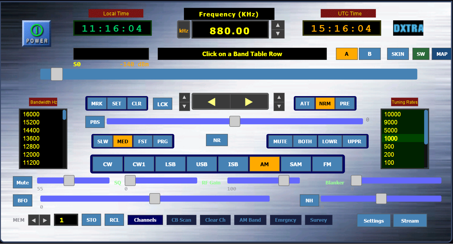
What is Radio Remote Control?
This is the ability to control a radio receiver through an embedded serial port, USB port, Ethernet, or WiFi connection. Generally speaking, the radio has an embedded microcontroller that can receive and act on simple commands sent from a control program like WorldStation. So you can use your PC's mouse and keyboard to remotely control the receiver.
Why is this a big deal? Several reasons. One is you can locate the radio anywhere there is an internet connection and power and tune it remotely. Another reason is that you can integrate point-and-click databases that directly tune the receiver. This allows you to click through hundreds of frequencies in a short amount of time.
And lastly, you can automate scanning and other high-level functions automatically. WorldStation 5.0 can automatically scan banks of frequencies, get the signal strength of each channel and build up a long-term propagation chart overnight — for example, the AM band Clear Channels.
In the modern era, with advanced networking, your radio is also networked with fellow radio users, so you can chat and see (and listen) in real-time to what other users are hearing. The list goes on.
One other note: higher-end receivers and SDRs allow for fine detail control over many other radio features such as noise reduction, special demodulation modes, bandwidths, and more.
Longley-Rice ITM Propagation Model
The Irregular Terrain Model (ITM), commonly known as Longley-Rice, was developed by the National Telecommunications and Information Administration (NTIA) at the Institute for Telecommunication Sciences (ITS) in Boulder, Colorado. It predicts radio signal propagation loss over irregular terrain for frequencies between 20 MHz and 20 GHz.
How It Works
For each FM station, the model traces signal paths along 360 radial bearings from the transmitter. Along each path, it samples terrain elevation from SRTM 1-arc-second data (approximately 30-meter resolution) to build a terrain profile. The model then calculates signal attenuation caused by terrain features: hills, valleys, ridges, and diffraction over obstacles. The result is a predicted field strength at each point around the transmitter.
Industry Use
Longley-Rice is the standard propagation model used by the FCC for broadcast station licensing and interference analysis. It is also widely used in cellular network planning, public safety communications, land mobile radio, and military spectrum management. Its terrain-awareness makes it far more accurate than simple distance-based models, especially in hilly or mountainous regions.
On This Site
Full Longley-Rice contours have been computed for all 53,000+ FM stations across the US, UK, Europe, Brazil, Australia, Thailand, South Africa, and Chile, using actual SRTM terrain profiles with up to 360 radial bearings per station. All computations are performed on Dxtra's in-house computing cluster. Two contour levels are shown: the city-grade (60 dBuV/m) contour representing reliable indoor and mobile reception, and the DX contour (40 dBuV/m) representing the outer limit of usable reception with a rooftop directional FM Yagi antenna with a rotator.
Data Sources
- FCC CDBS — AM and FM engineering data (call signs, frequencies, power, antenna patterns, coordinates, licensee information)
- SRTM Elevation Data — NASA Shuttle Radar Topography Mission 1-arc-second terrain tiles, used for Longley-Rice path profiles
- Ofcom — UK FM and AM/MW station technical parameters and licensing data
- BNetzA — European FM station data from Germany's Federal Network Agency
- ANFR — French FM station data from the Agence Nationale des Fréquences (replaces BNetzA data for France with authoritative ANFR records)
- ANATEL — Brazilian FM and AM station data from the national telecommunications agency
- ACMA — Australian FM and AM station data from the Register of Radiocommunications Licences
- ICASA — South African FM and AM station data from the Independent Communications Authority of South Africa
- SUBTEL — Chilean FM and AM station data from the Subsecretaría de Telecomunicaciones
- AsiaWaves — FM station data for Thailand, Malaysia, Singapore, and Brunei from asiawaves.net
- ITU-R P.1147 — MF skywave field strength prediction model for AM nighttime propagation
- US Census — Population data for estimating station audience reach
Technology
All propagation modeling, coverage maps, and heatmaps are computed by Dxtra's in-house computing cluster. Interactive maps use Leaflet.js. No web frameworks, no build tools, no JavaScript bundlers.
Professional & Bulk Data
Need coverage maps, contour data, or station databases in bulk for commercial or research use? We offer professional data packages including Longley-Rice coverage polygons, heatmap tiles, and full station technical parameters across all supported countries. Contact us at info@dxtra.com to discuss your requirements.
Contact
For questions, corrections, or feedback: info@dxtra.com